الفترة البيزنطية
بدأت الفترة البيزنطية عام 324م مع بداية ظهور الإمبراطورية الرومانية الشرقية أو البيزنطية وانتهت عام 636م بانتهاء سيطرة الرومان الشرقيين على المنطقة في معركة اليرموك عام 636م.
ومع ظهور السيد المسيح عليه السلام، بدأت المسيحية تنتشر في الأردن، خاصة بعد فرار المسيحيين الأوائل من القدس إلى بيلا حوالي عام 70 م، والتي وفرت لهم الحماية وحرية العبادة.
وخلال فترة حكم الإمبراطور الروماني فيليب للمنطقة (244م-249م) نمت الديانة المسيحية بشكل ملحوظ، وزاد انتشارها في عهد الامبراطور قسطنطين (بين عامي 306م و337م) الذي اعتنق المسيحية، وعمل على توسيع سلطة الكنيسة المسيحية في الإمبراطورية الرومانية.
ازدهرت المنطقة خلال هذه الفترة نتيجة استقرارها وانتعاشها الاقتصادي من خلال الزراعة والتجارة والصناعة، فزاد عدد سكان المدن وأعيد إعمارها وبنيت فيها الكنائس والأديرة وزيّنت ارضياتها بالفسيفساء. زرعت الأراضي خاصة بالحبوب والزيتون والعنب وصدّرت إنتاجها من الزيت والحبوب، وصنعت النبيذ وصدرته، كما طوّرت نظام سكّ النقد فأصبحت العملة تحمل رقما يمثل قيمتها.
ومع أن مدينة إربد (ارابيلا) حاليًا تخلو من الآثار البيزنطية، لكن لا شكّ أنها احتضنت عددًا من الكنائس كما هو الحال في جميع أرجاء الأردن.
أم قيس (جدارا)
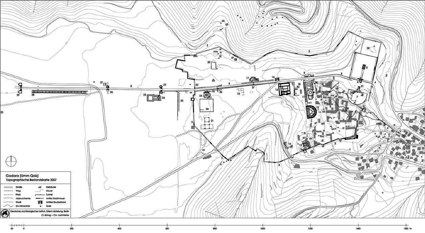
تقع جدارا إداريًا في لواء بني كنانة على بعد 28 كم شمال مدينة إربد، في أقصى الشمال الغربي للأردن حيث تطل على وادي الأردن وبحيرة طبريا ونهر اليرموك وهضبة الجولان السورية.
يتكون الموقع من التل (الأكروبولس) في الجهة الشرقية منه بمساحة خمسة هكتارات، والمنطقة الواقعة إلى الغرب من التل بمساحة 25 هكتارًا.
كانت جدارا اليونانية الرومانية إحدى مدن حلف الديكابوليس التي ازدهرت وكبرت مساحتها إلى 30 هكتارًا، وأقيم بها مجموعة من الشوارع الفرعية باتجاة شمال -جنوب تقاطع الشارع الرئيسي الدكيومانوس ماكسموس، أشهر هذه الشوارع شارع الكاردو الذي يمر باتجاه الشمال من أمام المسرح الغربي والمتاجر حتى الوصول الى سبيل الحوريات على الضفة الشمالية من شارع الدكيومانوس ماكسموس.
اقيمت بالمدينة الساحات مثل الساحة المفتوحة المسماة (Periste courtyard)، وخمس بوابات رئيسية على طول شارع الديكيومانوس، وأربعة حمامات، ومعابد وكنائس ومباني عامة، وقرية عثمانية مبنية على أعلى التل. لقّبت المدينة بمدينة الفلاسفة والشعراء لكثرة الفلاسفة والشعراء الذين عاشوا فيها أمثال ميلياغروس، وثيودوروس، فيلوديموس.
من أشهر نقوش جدارا باللغة اليونانية، شاهد قبر من عمل أرابيوس، أرّخ للعام 355م، وجد على أحد القبور، ويقول: "إليك أقول أيها المار من هنا، كما أنت الآن كنت أنا، وكما أنا الآن ستكون أنت، فتمتع بالحياة لأنك فان". (زيادين 1973).
بدأ استيطان المدينة على تلة الأكروبوليس حوالي النصف الثاني من القرن الثالث قبل الميلاد حيث عثر على فخار مستورد وامفورات مختومة (قوارير فخارية مختومة) بالتاريخ نفسه.
ضمّ الأكروبوليس الهللينستي حوالي القرن الثاني قبل الميلاد، معبدًا للإله زيوس وسورًا للمدينة آثاره واضحة في الجهة الجنوبية. تطورت المدينة خلال العصر الروماني وتوسعت غربًا على طول شارع الدكيومانوس ماكسموس الذي يبلغ طوله حوالي 1.5 كم، وأصبحت عضوًا في رابطة الديكابوليس (Bührig 2003، هوفمان 2002).
من أمثلة التطور: بناء البوابة الشرقية (بوابة أبيلا)، توسعة السور الهلنستي، وتشييد المسرح الشمالي على السفح الشمالي للأكروبوليس وبوابة طبريا ومضمار سباق الخيل الغربي خلال القرن الأول الميلادي، بناء المسرح الغربي وسبيل الحوريات والمقبرة الملكية تحت الأرض خلال القرن الثاني الميلادي، بناء البوابة التذكارية وميدان سباق الخيل في بداية القرن الثالث الميلادي، وحمامات هيراكليدس (Bührig 2008، 2011).
أزدهرت المدينة خلال الفترة البيزنطية على الرغم من تأثرها بالزلزال الذي ضرب المنطقة خلال القرن الرابع أو أوائل القرن الخامس الميلادي. وخلال هذه الفترة أصبحت أبرشية داخل الأرض المقدسة (Bührig 2009:373)، وبني العديد من المباني والمتاجر على طول شارع الديكومانوس ماكسيموس وأنحاء أخرى من المدينة، مثل: مجمع الحمامات البيزنطي الكبير (نيلسن وآخرون 1993) وخمس كنائس أهمها: البازيليكا ذات الخمسة أجنحة خلال القرن الرابع الميلادي (ويبر وهوبنر 1998)، الكنيسة المركزية والبازيليكا ذات الثلاثة أجنحة في الزاوية الجنوبية الغربية من تلة المستوطنة القديمة خلال القرنين السادس والسابع (Bührig 2009).
كشف في المدينة عن مجموعة من التماثيل صنع معظمها من الرخام المستورد من اليونان وتركيا (صورة 5- 6- 7)، وهي معروضة في متحف الموقع (متحف أم قيس).
من أهم هذه التماثيل تمثال أرتيميس الذي كشف عنه داخل المنصة التذكارية بجانب سبيل الحوريات وأرخ للنصف الثاني من القرن الأول الميلادي، وتمثال الإله زيوس الذي كشف عنه في المعبد الهللينستي على الأكروبوليس وأرخ الى القرن الثاني أو الثالث الميلادي. وتمثال تايكي الذي كشف عنه في المدرج الغربي وأرخت إلى الربع الثاني من القرن الثاني الميلادي.
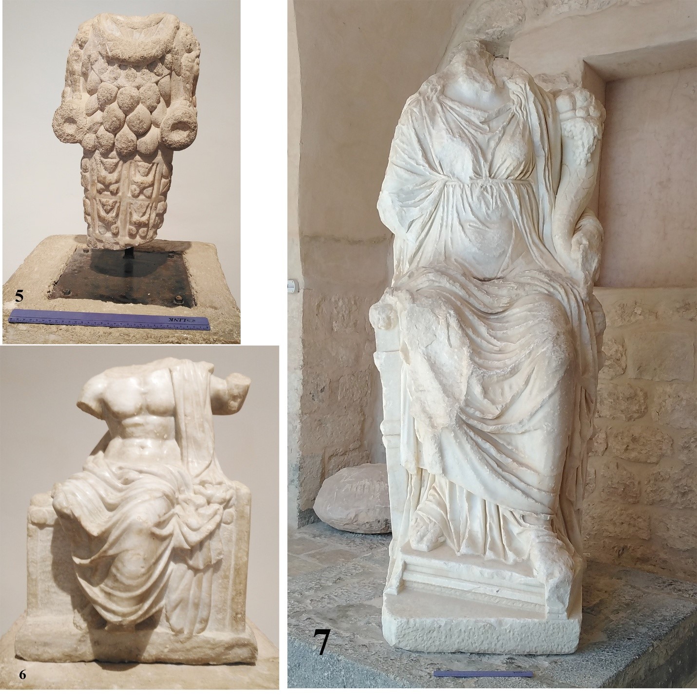
7- تايكي ، 6- زيوس، 5- ارتيمس.
يشار إلى أن المدينة تمتلك نظامًا مائيًا متكاملًا تجري المياه في قنوات ظاهرة وتحت الأرض لتغذي الآبار المنتشرة في جميع أجزاء الموقع. جلبت المياه من عيون وينابيع تحيط بالموقع، ونقلت المياه من سوريا إلى أم قيس وباقي مدن الديكابوليس بقنوات ونفق امتدّ من بلدة داعل إلى أم قيس، وتفرع ليصل مدن الديكابوليس.
Bührig, C. (2011).
بيت راس (كابيتولياس)
بيت راس (كابتولياسCapitolias )، إحدى مدن الديكابوليس، التي تأسست قبل عام 97/98م بناء على قطع من النقود كشف عنها في المدينة. يقع الموقع الأثري شمال مدينة إربد على بعد حوالي 5 كم من مركزها على تلة ترتفع حوالي 600 متر عن مستوى سطح البحر.
أخذت المدينة اسمها Capitolias من اسم معبد للإله جوبيتر سمّي جوبتير كابيتوليانس Jupiter Capitolinus، والذي تم بناؤه على التلة ويَظهر منقوشًا على عملات نقدية تؤرخ للسنوات 165-166م اكتشفت في المدينة.
ويطابق الاسم الحديث بيت راس التسمية الرومانية حيث تعني كابتو المكان المرتفع أو الرأس ولياس تعني بيت (السكن).
تقع الكثير من آثار المدينة تحت المباني الحديثة التي أخفتها، كما أنّ أعادة استخدام الحجارة في بناء المساكن أدى إلى ضياع معالم الباني الأثرية، وعلى الرغم من ذلك ما تزال هناك بعض المعالم ظاهرة للعيان، وبعضها تم الكشف عنه بحفريات دائرة الآثار العامة والبعثات الأجنبية خلال العقود الماضية.
من أهم المعالم الأثرية التي كشف عنها في الموقع الأثري:
الشارع الروماني الذي يقطع المدينة من الشرق الى الغرب، وما يزال على جانبه الشمالي تمثل معالم من تسع أقبية وبجوارها كنيسة.
سور المدينة الروماني التي يحيط بها حيث اكتشفت أجزاء واسعة منه خلال الحفريات التي جرت في السنوات الماضية واخرها في المسرح الذي كشف عنه عام 1999م .
المسرح الواقع شمال المدينة ويطل نحو الشمال. أقيمت أساسات المسرح في النصف الثاني من القرن الثاني الميلادي على منحدر التل الذي يتكون من صخور تكوين أم رجام الصواني (حجر جيري فاتح اللون يحمل عقيدات الصوان). يشبه المسرح في الهيكل العام والتفاصيل المسارح اليونانية والرومانية الأخرى من حيث وجود غرف تبديل الملابس والمنصة والأوركسترا والمدرج والممر والشرفة العلوية وغيرها. تُعد الزلازل والانهيارات الأرضية أهم أسباب طمر المسرح كاملا وظهور جداره الشمالي فقط حيث اعتقد الرحالة والاثاريين لفترة طويلة أنه جزء من سور المدينة.
4- بركة رومانية كبيرة الحجم يغطي بعض أجزائها طبقة من الملاط.
في الفترة البيزنطية، بقيت المدينة مزدهرة، فقد كشف عن ثلاث كنائس فيها: الكنيسة قرب الجامع: بنيت في القرن الخامس الميلادي على نظام البازليكا، الكنيسة الشمالية: اكتشف فيها نقش كتب على لوح رخام باليونانية “أبناء أركاديوس” ، على الأغلب هو إشارة إلى المتبرعين، وكنيسة عطروز: وهي بازيليكا أرضيتها مزخرفة بالفسيفساء بنيت في القرن السادس أو السابع
الميلادي (قاقيش: 2007). كما تنتشر في المدينة العشرات من معاصر العنب التي جعلت من المدينة أحد أكبر مصنعي ومصدري النبيد (ملحم 1992).
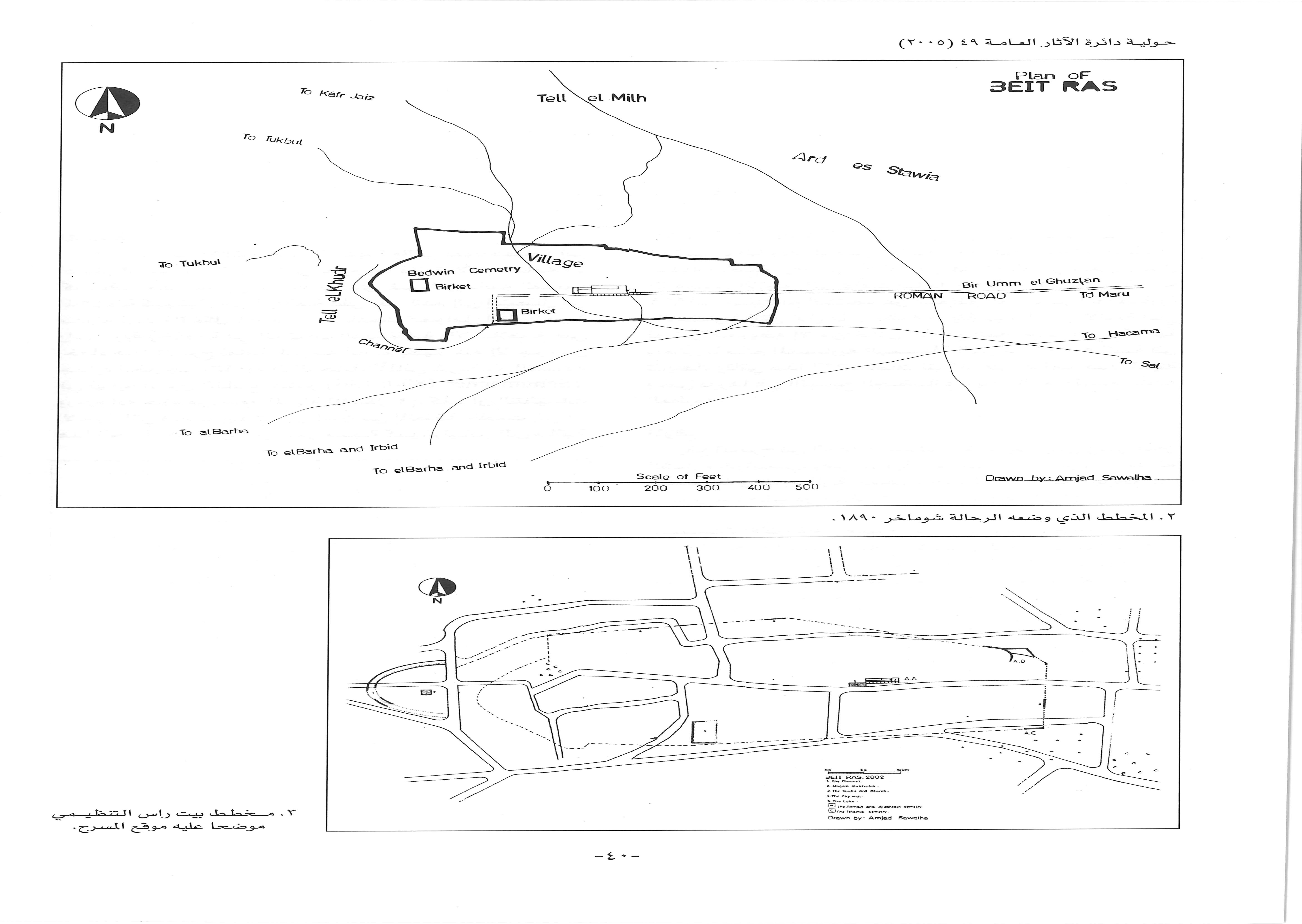
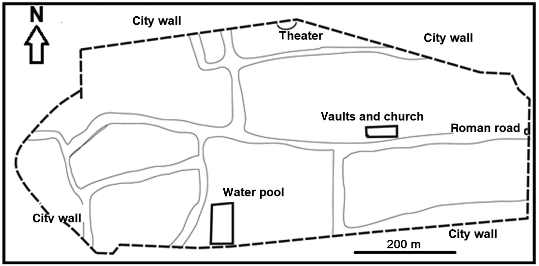
مخطط بيت راس (طوالبة واخرون 2021).
كما كشف عن العديد من المدافن في المدينة، كان آخرها المدفن الذي كشف عنه بالقرب من المدرسة عام 2016م. تبرز أهمية المدفن إلى ما يحتويه من 65 نقش بالآرامية واليونانية، ويبرز 270 شخصية، ويرسم مراحل إنشاء كابيتولياس بالتفصيل على لوحات فريسكو ما تزال محفوظة على جدران غرفة الدفن الرئيسية، كما يعرض على سقفه البروج والكواكب في تكوين دائري تحيط به وحوش البحر (Haron and Adarbeh 2021).
قويلبة (أبيلا)
أبيلا إحدى مدن الديكابوليس التي تتبع إداريا لواء بني كنانة على بعد 18 كم شمال مدينة إربد، يتكون الموقع من تلين (تل أبيلا شمالًا، وتل أم العمد جنوبًا) بينهما سرج. إلى الشرق من هذين التلين، يمتد وادٍ قديم، يغذيه نبع عين قويلبة.
أظهرت المسوحات والحفريات الأثرية خلال العقود الماضية أن أبيلا كانت مدينة مزدهرة خلال العصر البيزنطي، وبلغ عدد سكانها حوالي 8000-10000 نسمة.
دلّ التتابع الطبقي في التل الشمالي أن له تاريخ استيطاني يعود على الأقل إلى العصر البرونزي المبكر (العصر البرونزي الأول)، تعلوه كنائس بيزنطية. يربط جسر روماني بلغ ارتفاعه 5 أمتار، غرب الوادي بشرقه، حيث توجد على امتداد المنحدر مئات القبور المنحوتة في الصخر والمزخرفة بالفريسكو.
طغت الآثار البيزنطية على الموقع، ومع ذلك، هناك شواهد قليلة من الفخار على الفترة الهللينستية والعديد من الشواهد على الآثار الرومانية.
أولها: العملات التي سكت فيها خلال القرنين الثاني والثالث الميلاديين، وعملات من مدن الديكابوليس استخدمت فيها خلال الفترة الرومانية.
ثانيها: السيراميك الروماني الذي كشف عنه في الموقع وخاصة أعلى تل آبل (التل الشمالي) وفي السرج أسفله.
ثالثها: نقوش مختلفة تمّ تأريخها إلى القرن الفترة الرومانية.
رابعها: قبور مزخرفة من الفترة الرومانية المتأخرة. أضف إلى ذلك الآثار المعمارية التي أثبتت الحفريات في السنوات الأخيرة تأريخها للفترة الرومانية وتشمل الجسر، ومجمع الحمامات وسبيل الحوريات (شرق تل آبل) والمعبد على تل آبل، وشارع الديكيومانوس، بالإضافة إلى بقايا المباني التي كشف عنها شمال شرق الكنيسة البيزنطية أعلى تل آبل (منطقة AA).
وهناك الكثير من اللقى من الأدوات البيزنطية، كما تغطي الموقع آثار الفترة البيزنطية المعمارية، ويوجد على الأقل خمس كنائس موزعة في أنحاء الموقع: البازيليكا المصلبة في المنطقة E (المسماة مجمع الحج) الواقعة على أدنى شرفة من السرج، ويعود تاريخها إلى أواخر القرن الخامس أو أوائل القرن السادس الميلادي (مينينجا 2004، ماري 1996)، وكنيستي أم العمد في المنطقة D وكنيسة المنطقة DD على تل أم العماد ويعود تاريخهما إلى القرن السابع الميلادي (وينتر 1992، فولر 1987)، وكنيسة المنطقة A على تل آبل وتأرخ إلى القرن السادس الميلادي، وكنيسة المنطقة G التي تقع جنوب شرق المسرح وتأرخ إلى أواخر القرن السادس الميلادي.
كما يوجد العديد من المقابر البيزنطية المنحوتة بالصخر والمزينة بالفريسكو، ويؤرخ بلاط شارع الديكيومانوس البازلتي إلى هذه الفترة.
طبقة فحل
بيلا إحدى مدن الديكابوليس وتقع في الأغوار الشمالية على بعد 33 كم من مدينة إربد. يضم الموقع تلّين: تل طبقة فحل (التل الرئيسي)، وتل الحصن المُحاط بوديان خصبة (ماكومبر 1992).
ازدهرت بيلا تجاريًا وتوسعت سكانيًا خلال القرن الثاني وأوائل القرن الأول قبل الميلاد من الفترة الهللينستية، بالإضافة إلى قدر كبير من العمارة المحلية كشف فيها عن أسرجة من أثينا، وزجاجًا، وعملات أرخت إلى النصف الثاني من القرن الثاني قبل الميلاد، وبضائع مستوردة من الجزر اليونانية (سميث، 1981). بعد تدمير الحشمونيون للمدينة في عام 82/83 ق.م.
تعافت المدينة وازدهرت تجاريًا، فبنيت فيها حصون كأبراج مراقبة لحماية المدينة المزدهرة (تشيرشر، 2008).
خلال الفترة الرومانية دخلت المدينة إلى حلف مدن الديكابوليس واستقبلت مسيحيي القدس الذين قدموا إليها بحثًا عن الأمان من حصار الرومان للقدس الذي قدموا لإخماد الثورة اليهودية في الفترة من 66 إلى 70 ميلاديًا، عاد المسيحيون إلى مدينة القدس المدمرة عام 130 ميلاديًا.
دلّت الصور على العملات على ازدهار بيلا الرومانية فرسمت عليها مبان في الوادي، ومعابد ذات أعمدة، وشوارع. وكشفت الحفريات عن مقابر رومانية، عثر فيها على مصابيح، وأوانٍ فخارية، وقوارير زجاجية (تشرشر، 2008).
من أهم المباني التابعة لهذه الفترة الأوديون أو المدرج الروماني الذي أرخ للقرن الأول الميلادي، وهو يتوسط الموقع حيث يقع على مجرى وادي الجرم ضمن المجمع المدني الذي يضم بقايا حمام ومعبد أو مبنى عقائديًا أو قاعة اجتماعات.
استمرت بيلا في الازدهار خلال الفترة البيزنطية فبنيت فيها الكنائس والأديرة والمباني السكنية والمباني العامة، التي ازدحمت جميعها على المنحدرات والتل الرئيسي، بالإضافة إلى عدد كبير من معاصر إنتاج النبيذ.
كان للمدينة أسقفها الخاص الذي شارك في مجمع أفسس (Ephesus) عام 449 م، ومجمع خلقيدونية (Chalcedon) عام 451 م.
من أهم آثار العصر البيزنطي الكنائس البازيليكية الثلاث التي شُيّدت في المدينة: - - الغربية عند الطرف الغربي للتل وأرخت للقرن السادس الميلادي.
-على الجانب الشرقي من المدينة على سفح جبل أبو الخس وأرخت للقرن الخامس الميلادي،
-كنيسة المجمع المدني في وادي الجرم وأرخت للقرن السادس الميلادي ويحتمل ان تكون كتدرائية بسبب حجمها وموقعها.
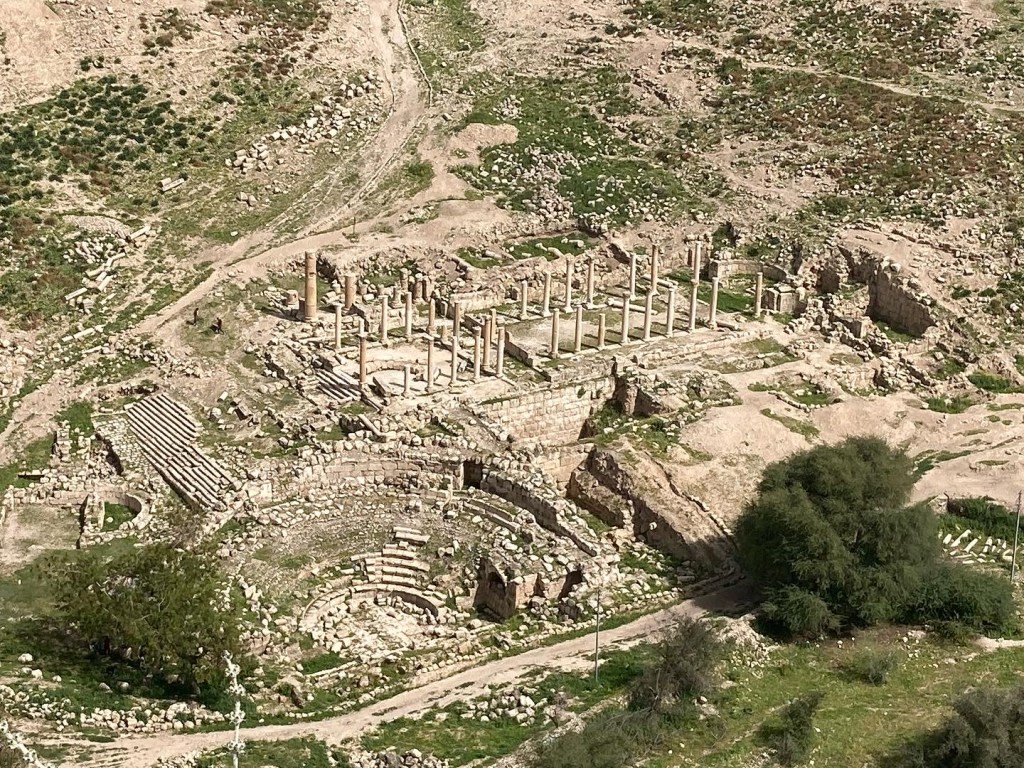
ويمكن تتبع الآثار في الكثير من المدن والبلدات والخرب المنتشرة في جميع أنحاء محافظة أربد، من الأمثلة على ذلك اليصيلة، دوحلة، يعمون، بيت ايدس.
اليصيلة
يقع موقع اليصيلة الأثري على بعد حوالي 9 كم إلى الشرق من إربد في منطقة خصبة وغزيرة المياه، حيث يمر بالموقع وادي اليصيلة.
من آثار الفترة الهللينستية، الفخار الهللينستي الذي كشفت عنه الحفريات الأثرية بالإضافة إلى فخار من الفترات الرومانية والبيزنطية وبكميات أقل من الفترات الإسلامية، وكذلك مبنى هللينستي بطابقين وعدة غرف ومخزن وآبار.
من من الآثار الرومانية المدافن النتشرة على المنحدر الشرقي لوادي الشلالة القريب من الموقع، ومن الآثار البيزنطية كنيستين بازيليكيتين أرخت الأولى لمنتصف القرن الخامس أو بداية القرن السادس الميلادي، وأرخت الثانية للعام 528م.
دوحلة
يقع موقع دوحلة أو خربة دوحلة على بعد حوالي 25 كم جنوب شرق إربد، ويرتفع حوالي 900 متر فوق سطح البحر على طول الطرف الجنوبي لوادي الزاغ.
تم استيطان الموقع من الفترة الرومانية وحتى أواخر العصور الإسلامية. وكشف المسح والتنقيب الأثري عن العديد من المباني والمقابر والكهوف ومسجد وآبار.
يوجد في الموقع ثلاث مقابر تم تأريخها للفترتين الرومانية والبيزنطية بناء على الفخار الذي وجد به. كما كشف فيها عن أرضية فسيفساء بيزنطية.
تل يعمون
يقع تل يعمون الأثري على بُعد 25 كم جنوب شرق مدينة إربد، على ارتفاع حوالي 800 متر فوق مستوى سطح البحر.
كشفت المسوحات والحفريات في التل وما حوله أن الموقع تمّ استيطانه منذ العصور البرونزية وحتى الإسلامية.
خلال الفترة الكلاسيكية ظهرت معاصر النبيذ والزيتون الهللينستية بشكل رئيسي في الجزء الغربي من التل، ووجدت المقابر الفردية والمتعددة في جنوب التل تعود للفترة الرومانية والبيزنطية، وعلى الجهة الشرقية من التل توجد الكنيسة البيزنطية التي بنيت على النظام البازيليكي في نهاية القرن الخامس وبداية القرن السادس الميلادي وتضم عددًا من الكتابات وأرضية فسيفسائية مزخرفة بالنباتات والأسماك والطيور وغيرها.
فسيفساء كنيسة تل يعمون (Turshan 2010).
بيت إيدس
تقع بلدة بيت إيدس على بعد حوالي 20 كم غرب إربد. تشتهر البلدة بكنيستها الواقعة على بُعد حوالي 5 كم غربها وحوالي 5.5 كم شمال شرق مدينة بيلا.
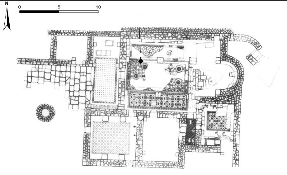
بينيت الكنيسة على النظام البازيليكي وتتكون من صحن وممرين، تفصل بينهما مجموعتان متوازيتان من ثلاث قواعد أعمدة.
كشفت الحفريات الأثرية على خمسة نقوش، منها نقوش تكريسية. ويُحدد هذا النقش شهر وسنة وضع الفسيفساء إلى فبراير 507، ولكن دون ذكر اسم الأسقف أو الولاية التي تنتمي إليها الكنيسة أو الموقع. ولهذا السبب ربما يعود بناء الكنيسة إلى عام 444م إذا كانت تابعة لحلف الديكابوليس نظرًا لقربها من بيلا وجدارا، أو يعود بناؤها إلى عام 613 م في حال تبعيتها لأبرشية بصرى وولاية الجزيرة العربية.
مخطط كنيسة بيت ايدس (ملحم 2000).
The Byzantine Period
Commencing in 324 AD with the emergence of the Eastern Roman (Byzantine) Empire, the Byzantine period ended in 636 AD with the defeat of the Eastern Romans in the Battle of Yarmouk, furthermore, with the advent of Jesus Christ, peace be upon him, Christianity began to spread in Jordan, especially after early Christians fled from Jerusalem to Pella around 70 AD where they were granted protection and freedom of worship, thus during the reign of the Roman emperor Philip (244–249 AD), Christianity grew and spread further during the reign of Emperor Constantine (306–337 AD), who embraced Christianity and worked to expand the authority of the Christian Church within the Roman Empire.
During this period of stability and economic growth driven by agriculture, trade, and industry, the region prospered, city populations increased, cities were rebuilt, lands were cultivated, churches and monasteries were constructed, and their floors were decorated with mosaics. Lands were cultivated and focused on the production of grains, olives, and grapes, and the export of both oil and grain, in addition to the production and export of wine and the coinage system was developed so that currency bore a number representing its value. A fact worth considering that although, presently, the city of Irbid (Arabella) lacks visible Byzantine remains, there is no doubt that it once contained several churches, as was the case throughout Jordan.
Umm Qais (Gadara)
Gadara is, administratively, located in Bani Kinana District, approximately 28 km north of the city of Irbid, in the far northwestern part of Jordan, overlooking the Jordan Valley, Lake Tiberias (Sea of Galilee), the Yarmouk River, and the Syrian Golan Heights, consisting of the hill (Acropolis) on its eastern side, covering an area of five hectares, and the area located to the west of the hill, covering 25 hectares.
A city of the Decapolis League, Greek–Roman Gadara flourished and expanded to an area of 30 hectares, coupled with a network of secondary streets running from north to south and intersecting with the main street, the Decumanus Maximus, the most prominent of which was the Cardo which ran northward in front of the Western Theater and shops, reaching the Nymphaeum on the northern side of the Decumanus Maximus.
Known as the City of Philosophers and Poets due to being inhabited by many philosophers and poets, such as Meleager, Theodorus, and Philodemus, it contained public squares, including the open square known as the Peristyle Courtyard, five main gates along the Decumanus, four bath complexes, temples, churches, public buildings, and an Ottoman village built on the highest part of the Acropolis hill, which was officially settled in around the second half of the third century BC, as evidenced by the discovery of imported pottery and stamped amphorae dating to the same period. Gadara boast one of the most famous Greek inscriptions on a carved tombstone discovered on one of the graves and carved by Arabios, dating back to 355 AD: “To you, passerby, I say: as you are now, so once was I; and as I am now, so you shall be. Therefore, enjoy life, for you are mortal.” (Zayadin 1973).
During the second century BC, the Hellenistic Acropolis included a temple dedicated to the god Zeus and a city wall, traces of which remain visible on the southern side, and the city developed during the Roman period and expanded westward along the Decumanus Maximus, which is approximately 1.5 km in length, and it became a member of the Decapolis League (Bührig 2003; Hoffmann 2002).
Major constructions were a clear representation of this development include the construction of the Eastern Gate (Gate of Abila), the expansion of the Hellenistic wall, the construction of the Northern Theater on the northern slope of the Acropolis, the Tiberias Gate, and the Western Hippodrome during the first century AD, the construction of the Western Theater, the Nymphaeum, and the royal underground tomb during the second century AD, in addition to the construction of the monumental gate and the hippodrome at the beginning of the third century AD, coupled with the Baths of Heracleides (Bührig 2008, 2011).
The city of Umm Qais (Gadara) flourished during the Byzantine period, despite being affected by an earthquake that struck the region during the fourth or early fifth century AD, during which, Gadara became a bishopric within the Holy Land (Bührig 2009:373), where numerous buildings and shops were constructed along the Decumanus Maximus and in other parts of the city, including the large Byzantine bath complex (Nielsen et al. 1993) and five churches, the most important of which are the five-aisled basilica dating to the fourth century AD (Weber and Hübner 1998), as well as the central church and the three-aisled basilica located at the southwestern corner of the ancient settlement hill, dating to the sixth and seventh centuries AD (Bührig 2009).
A collection of statues presently displayed in the site museum (Umm Qais Museum) were uncovered in the city, most of which were made of marble imported from Greece and Turkey (Figures 5–6–7), among the most important of these statues are the statue of Artemis, discovered within the monumental platform beside the Nymphaeum and dating back to the second half of the first century AD, the statue of the god Zeus, discovered in the Hellenistic temple on the Acropolis and dated to the second or third century AD, and the statue of Tyche, discovered in the Western Theater and dated to the second quarter of the second century AD.
4 – Artemis, 5 – Zeus, 6 – Tyche.
It should be noted that the city possessed a fully integrated water system, in which water flowed through open channels and underground conduits to supply wells distributed throughout all parts of the site. Water was brought from springs and water sources surrounding the site, and water was also conveyed from Syria to Umm Qais and the other Decapolis cities through channels and a tunnel extending from the town of Dael to Umm Qais, branching out to reach the cities of the Decapolis.
Bührig, C. (2011).
Beit Ras (Capitolias)
Another member of the Decapolis League of cities, Beit Ras (Capitolias) which was founded prior to 97/98 AD, based on the coins discovered in the city, and the archaeological site is located north of the city of Irbid, approximately 5 km from its center, on a hill rising about 600 meters above sea level.
The city took its name Capitolias from a temple dedicated to the god Jupiter, known as Jupiter Capitolinus, which was built on the hill and appears engraved on coins dated to 165–166 AD that were discovered at the site, and its modern name Beit Ras corresponds to the Roman designation, where Capito means “the elevated place” or “the head,” and Lias means “house” (dwelling).
Many of the city’s remains are concealed by modern buildings built on top of them and they were also disfigured and their architectural features lost to the frequent reuse of their stone in the construction of houses, nevertheless, several landmarks remain visible, and others have been uncovered through excavations conducted by the Department of Antiquities and foreign missions over past decades, among the most famous of which are: First, the Roman street that cuts through the city from east to west, along whose northern side remain features of nine vaulted structures, adjacent to a church, second, the Roman city wall that surrounded the city, large sections of which were uncovered during excavations carried out in recent years, most recently in the theater, which was revealed in 1999 AD, third, the theater, located north of the city and facing north with its foundations of the theater laid in the second half of the second century AD on the slope of the hill, which consists of rocks from the Umm Rijam Chert Formation (light-colored limestone containing chert nodules), and resembling other Greek and Roman theaters in its general structure and details, including changing rooms, the stage, orchestra, cavea (seating tiers), passageways, upper gallery, and other elements. The theatre was destroyed and completely buried due to earthquakes and landslides leaving only its northern wall visible, which led travelers and archaeologists for a long time to believe that it was part of the city wall, fourth, a large Roman pool, parts of which are covered with a layer of plaster.
During the Byzantine period, the city remained religiously and economically prosperous boasting three uncovered churches, namely the church near the mosque, built in the fifth century AD in the basilica style, the northern church, where an inscription in Greek carved on a marble slab reading “The Sons of Arcadius” was discovered, most likely referring to the donors, and the Church of ‘Ataruz, a basilica with mosaic-decorated floors, built in the sixth or seventh century AD (Qaqish 2007), in addition to dozens of wine presses spread throughout the city, making it one of the largest producers and exporters of wine (Melhem 1992).
Plan of Beit Ras (Tawalbeh et al. 2021).
Furthermore, the city of Beit Ras (Capitolias) housed numerous burials, the most recent of which was a tomb uncovered near the school in 2016 AD, famous for its contents, which include 65 inscriptions in Aramaic and Greek, depicting 270 figures, and illustrating the stages of the establishment of Capitolias in detail through fresco panels that are still preserved on the walls of the main burial chamber, with a ceiling displaying the zodiac constellations and planets in a circular composition surrounded by sea monsters (Haron and Adarbeh 2021).
Qweilbeh (Abila)
Another member of the Decapolis league of cities, Abila, administratively affiliated with the Bani Kinana District, is located 18 km north of the city of Irbid, consisting of two hills, namely Tell Abila to the north and Tell Umm al-‘Amad to the south connected by a saddle between them, and to the east of these two hills extends an ancient valley fed by the spring of ‘Ayn Qweilbeh.
Archaeological surveys and excavations conducted over the past decades have shown that Abila flourished during the Byzantine period, with an estimated population of approximately 8,000–10,000 inhabitants, whereas stratigraphic sequences on the northern hill indicate a settlement history dating back at least to the Early Bronze Age (Early Bronze I), overlain by Byzantine churches, coupled with a Roman bridge, rising 5 meters in height, connecting the western side of the valley to its eastern side, where hundreds of rock-cut tombs, decorated with frescoes, extend along the slope.
Byzantine remains dominate the site, with limited evidence of Hellenistic pottery and numerous indicators of Roman-period occupation, including, first, coinage minted during the second and third centuries AD, as well as coins from other Decapolis cities used at the site during the Roman period, second, Roman ceramics uncovered throughout the site, particularly on the summit of Tell Abila (the northern hill) and in the saddle below it, third, various inscriptions dated to the Roman period, and finally decorated tombs from the Late Roman period.
Furthermore, recent excavations have confirmed Roman-period architectural remains, including the bridge, bath complex, nymphaeum (east of Tell Abila), the temple on Tell Abila, the Decumanus street, and remnants of buildings uncovered northeast of the Byzantine church at the summit of Tell Abila (Area AA), in addition to numerous Byzantine artifacts have been recovered, and Byzantine architectural remains cover much of the site, which include at least five churches are distributed across the area, first, the cruciform basilica in Area E (known as the Pilgrimage Complex), located on the lowest terrace of the saddle, dating back to the late fifth or early sixth century AD (Menninga 2004; Marei 1996), second, the two churches of Umm al-‘Amad in Area D and the church in Area DD on Tell Umm al-‘Amad, dating back to the seventh century AD (Winter 1992; Fuller 1987), the church in Area A on Tell Abila, dating back to the sixth century AD, and last the church in Area G, located southeast of the theater, dating back to the late sixth century AD. Furthermore, numerous rock-cut Byzantine tombs decorated with frescoes have also been identified, and the basalt paving of the Decumanus street dates to this period.
Tabaqat Fahl (Pella)
Another member of the Decapolis League of cities, Pella is located in the Northern Jordan Valley, approximately 33 km from the city of Irbid, comprising of two hills, Tell Tabaqat Fahl (the main mound) and Tell al-Husn, surrounded by fertile valleys (McComber 1992).
Pella flourished commercially and expanded demographically during the second century and early first century BC of the Hellenistic period, as confirmed by significant revealed local architecture along with imported Attic oil lamps, glass, and coins dating back to the second half of the second century BC, as well as imported goods from the Greek islands (Smith 1981). Following the Hasmonean destruction of the city in 82/83 BC, Pella recovered and regained its commercial prosperity, leading to the construction of fortifications such as watchtowers to protect the city (Chrichett 2008).
During the Roman period, the city joined the Decapolis and received Christian refugees from Jerusalem, who fled the Roman siege during the suppression of the Jewish Revolt between 66 and 70 AD, and who later returned to the destroyed city of Jerusalem in 130 AD.
Images on Roman coins attest to the prosperity of Roman Pella, depicting buildings in the valley, columned temples, and streets, in additions to Roman tombs containing lamps, ceramic vessels, and glass bottles uncovered by excavations (Chrichett 2008).
One of the most important Roman-period structures is the Odeon (Roman theater), dating back to the first century AD, located at the center of the site along the course of Wadi al-Jirm, within the civic complex that also includes remains of a bathhouse, a temple or cult building, or possibly an assembly hall.
Pella continued to flourish during the Byzantine period, with the construction of churches, monasteries, residential buildings, and public structures, densely occupying the slopes and main mound, along with a large number of wine-production presses.
The city had its own bishop, who participated in the Council of Ephesus (449 AD) and the Council of Chalcedon (451 AD) and boast three locally constructed basilica churches considered among the most important Byzantine remains in the city, first, the western basilica, at the western edge of the mound, dating back to the sixth century AD, second, a basilica on the eastern side of the city, on the slope of Jabal Abu al-Khas, dating to the fifth century AD, and finally the church of the civic complex in Wadi al-Jirm, dating back to the sixth century AD, and likely a cathedral due to its size and prominent location.
Archaeological remains can be traced across numerous cities, towns, and ruins spread throughout Irbid Governorate, including Al-Yaseelah, Duhlah, Yarmoun, and Beit Ides.
Al-Yaseelah
The archaeological site of Al-Yaseelah is located approximately 9 km east of Irbid, in a fertile, water-rich area traversed by Wadi al-Yaseelah, and is rich in Hellenistic-period remains such as Hellenistic pottery uncovered during excavations, along with pottery from the Roman and Byzantine periods, and smaller quantities from the Islamic periods, as well as a two-story Hellenistic building with multiple rooms, a storage area, and cisterns was also identified.
Furthermore, Roman-period remains also include tombs scattered along the eastern slope of Wadi al-Shallalah near the site, in addition to Byzantine remains of two basilica churches, the first dating back to the mid-fifth or early sixth century AD, and the second dating back to 528 AD.
Duhlah
The site of Duhlah, or Khirbat Duhlah, is located approximately 25 km southeast of Irbid, rising about 900 meters above sea level along the southern edge of Wadi al-Zagh, continuously inhabited since the Roman period until the late Islamic periods, a site where Archaeological survey and excavation revealed numerous buildings, tombs, caves, a mosque, and wells. Three tombs, based on the pottery found within them, and a Byzantine mosaic floor were identified as belonging to the Roman and Byzantine periods.
Tell Yarmoun
Located 25 km southeast of the city of Irbid, at an elevation of approximately 800 meters above sea level, the archaeological site of Tell Yarmoun was, according to conducted surveys and excavations conducted on the tell and its surroundings, inhabited since the Bronze Ages through the Islamic periods.
During the classical period, Hellenistic wine and olive presses appeared primarily in the western part of the tell, in addition to single and multiple tombs dating to the Roman and Byzantine periods were found in the southern part of the tell, whereas on the eastern side of the tell a Byzantine Basilica-architected church was constructed in the late fifth and early sixth centuries AD, which contains several inscriptions and a mosaic floor decorated with plants, fish, birds, and other motifs.
Mosaic of the Church of Tell Yarmoun (Turshan 2010)
Beit Ides
Located approximately 20 km west of Irbid, the town of Beit Ides is best known for its Basilica- architected church consisting of a nave and two aisles, separated by two parallel rows of three column bases, located about 5 km west of the town and approximately 5.5 km northeast of the city of Pella.
Archaeological excavations uncovered five inscriptions, including dedicatory inscriptions, of which one inscription specifies the month and year of the laying of the mosaic floor as February 507, without mentioning the name of the bishop or the province to which the church belonged to, or the site itself, thus the construction of the church may date back to 444 AD if it belonged to the Decapolis, given its proximity to Pella and Gadara, or to 613 AD if it belonged to the bishopric of Bosra and the province of Arabia.
Plan of the Church of Beit Ides (Milhim 2000).